How The Maps Are Made
Southeast Select, the culmination of a decade-long vision.
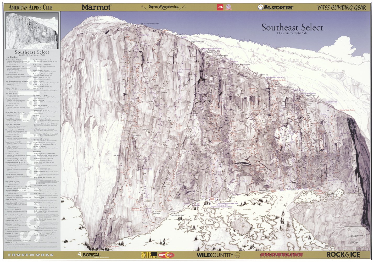
The original overview map of El Cap was first published in November 1996…
However with only 72 routes it could not define all the small variations and intricacies of El Cap’s right side. Additionally it was created by compiling all the published topos from existing guidebooks.
By 1998 the Half Dome poster was complete. This represented an entirely new level of research and accuracy. This was because there were no published topos of most of Half Domes routes. By contacting each ascensionist I was able to get first hand beta on every route.
This process led to the realization that topos are often erroneous, being copied from one book to the next and never revisiting the route itself. Therefore, with unwavering encouragement from Tom Frost and using his historic photograph of El Capitan, I began what became a year long project of drawing El Cap’s right side in the finest detail, while contacting ascensionists and drawing their lines onto the actual features.

“I began what became a year long project of drawing El Cap’s right side in the finest detail, while contacting ascensionists and drawing their lines onto the actual features.”
Clay Wadman
Utilizing telephoto pictures taken at different times and with different shadows, the face was artistically ‘expanded’ to show the oblique portion of the wall around the Wall of Early Morning Light. Once complete every route could be followed on the rendering. The exhaustive process of verifying and superimposing over 90 routes onto the poster became the crux. Free routes intermingled with old aid lines and modern routes criss-crossed and shared pitches with the classic lines.
Chris McNamara was a tremendous asset with his super topos. Additionally, thanks go out to Jim Beyer, Jay Smith, Conrad Anker, Bryan Law, Steve Gerberding, Ken Sauls, Steve Quinlan, John Middendorf, Matt Buckner, Jay Smith, Charles Cole, Jim Bridwell and the many others who gave me original and updated topos for nearly all the routes shown.
This comprehensive coffee table print is not for general reference, but is a resource for those who want to follow the obscure test pieces of El Cap's right side, either with a telescope in El Cap meadow, or a magnifying glass at home.